It was sold for $220,000 (£163,570) at Christie’s New York (25/20/12.5% buyer’s premium) on December 5.
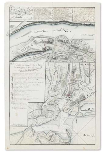
The larger ‘Carte generale de l’Isle de New York et des Environs’ offers an overall view of the harbour, from Sandy Hook in the south to present day Riverdale in the north, and from the Passac River in the west to Jamaica Bay in the east.
Certain areas of the map reflect French familiarity with the area, but others, such as British held Manhattan and eastern Long Island are more vaguely delineated.
One key feature is the narrow sandbar between the Narrows and Sandy Hook that was navigable only at high tide, and then only with ships sailing in single file and thus vulnerable to English guns.
The second, smaller map details the immediate vicinity of King’s Bridge. Spanning Spuyten Duyvil Creek, it was the only land crossing to Manhattan and one heavily guarded and fortified by British forces.


