The second of five reports on his Mexican campaigns that Cortés sent back to Spain and the Emperor Charles V, this record of his achievements and setbacks provided a valuable account of the Aztecs, their civilisation and their wealth, along with their practices of brutal human sacrifice.
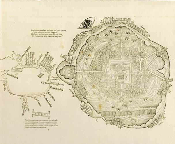
More significantly in auction terms, the copy offered in Munich also included the woodcut map of Tenochtitlan, the Aztec capital city, that is lacking in many, if not most recorded copies.
In ‘Mapping the Aztec Capital’, an article published in the journal Imago Mundi in 1998, Barbara Mundy wrote: “Once published in Europe, the city map [the source of which is unknown] and the companion map of the Gulf Coast, while certainly documentary, also assumed a symbolic function in supporting Cortes’ (and thereby Spain’s) just conquest of the Amerindian empire.”
The first plan of any urban site in the New World, the map of the city on Lake Texcoco shows temples, Montezuma’s palaces, numerous houses, canals and causeways. One large building, shown top left, flies a flag bearing the double-eagle emblem of the Hapsburgs, and is presumably where Cortés set up his headquarters.
Cortés went on to conquer the Aztecs and to destroy their capital, but the lake, long ago drained, is now the site of the world’s most populous urban centre, Mexico City.
The Gulf of Mexico map (with the south aspect at the top) is also the earliest chart of the area, the first to use the name Florida and the first to show the mouth of the river we now know as the Mississippi.
These maps were not printed in Spain at first, being considered secret, but with the appearance of this Nuremberg edition other European nations quickly gained their first picture of the Aztec capital.


