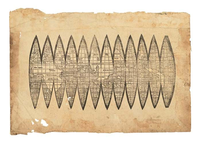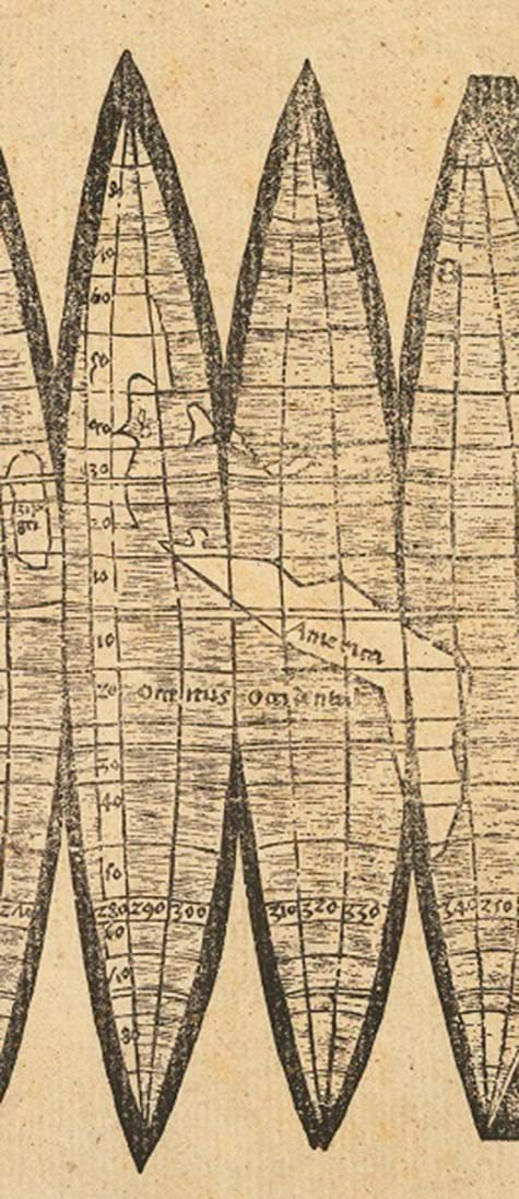
Produced by Martin Waldseemüller in 1507, the printed segments or gores would have made up the first recorded printed globe, one that not only named America but also illustrated both South and North American continents and a separate Pacific Ocean for the first time.
The globe, even with a diameter of just 4.5in (12cm), would offer a new and more accurate picture of the world in 360 degrees.
One of only five known copies* of the gores, Christie’s have estimated the lot at £600,000-900,000.
Defining Waldseemuller as the most important and innovative mapmaker of the early 16th century, Julian Wilson of Christie's notes that he had "...an enormous influence in the science of map-making and perhaps most significantly, defined history in naming America.”
Having in 1505 joined a group of scholars sponsored by René II, Duke of Lorraine and based at Saint-Dié-des-Vosges, near Strasbourg, Waldseemüller was tasked with creating a new edition of Ptolemy’s Geographia, a new globe and a large world map.
The latter, produced around the same time and also naming America, survives in a single copy that in 2003 was acquired from a German princely collection by the Library of Congress for $10m.
The New World
In his globe, say Christie's, Waldseemüller broke from standard cartographic conceptions to visualise Amerigo Vespucci’s claims that the North and South American continents might be separate from Asia. Waldseemüller boldly defined both the western coast of South America and Florida long before any European had officially seen it.
Could he and the scholars of Saint-Dié have had access to closely guarded information now lost from official records?
Only four earlier Western maps of the Americas survive in any form and three of those are manuscript portolan charts of c.1500-05. The only earlier printed map to show the Americas, the 1506 Contarini- Rosselli map that survives as a single copy in the British Library, depicts only a rudimentary outline.
Waldseemüller 's globe gores took into consideration the accounts of Vespucci, who in 1499 had voyaged further down the South American coast than earlier navigators and realised that the continent was far more extensive than had previously been believed.
Vespucci's announcement of his discoveries in Mundus Novus (Rome, c.1502) and his vivid description of the New World quickly became a bestseller around Europe, and it was in recognition of his world changing revelations that Waldseemüller named the continent in his honour.
* Three of the other recorded copies of the Waldseemüller gores are today to be found in the University of Minnesota Library, the Bavarian State Library and the City Library of Offenburg. A fourth remains in private hands, having sold at Christie's in 2005 for £480,000. That one differs from the others in having the gores already cut from the sheet, as if for mounting on a globe.


